Log in
All resources
Create a design
12,780 Free Images of Engraved Maps
joan blaeu
copper engraving print
copper engravings
british library
engraving
university of texas at arlington
maps by pieter van der keere
koninklijke bibliotheek
colored engraving on paper
17th-century maps of the mediterranean sea
nürnberger reichswald
1559 maps of germany
latin-language maps
german renaissance
maps in the staats- und universitätsbibliothek hamburg
1594 maps of hamburg
maps by isaak tirion
1751 maps
atlas maior, vol 11 (asia) - joan blaeu, 1667 - bl 114.h(star).11
1667 maps
maps in the staats- und universitätsbibliothek hamburg
maps of hamburg-altstadt
maps by isaak tirion
1751 maps
16th-century maps of the persian gulf
maps of the gulf of suez
maps of the dutch east india company - sri lanka
18th-century maps of sri lanka
victor levasseur - maps of france
neoclassicism,romanticism
jacques le moyne de morgues
1591 maps
atlas van der hagen (volume 2)
1680s maps of the netherlands
17th-century maps of prussia
baroque
17th-century maps of prussia
baroque
jacques le moyne de morgues
1591 maps
old maps of livonia
old maps of latvia
old maps of livonia
old maps of latvia
maps by daniel lizars
1831 maps of mexico
media from accademia delle scienze di torino
1577 engravings
media from accademia delle scienze di torino
1575 engravings
media from accademia delle scienze di torino
1577 engravings
media from accademia delle scienze di torino
1577 engravings
maps in the staats- und universitätsbibliothek hamburg
1594 maps of hamburg
maps by henry winkles
maps by john rapkin
maps by henry winkles
maps by john rapkin
old county maps of lancashire
copper engravings
maps by daniel lizars
1831 maps of mexico
old county maps of lancashire
copper engravings
maps in the staats- und universitätsbibliothek hamburg
maps of hamburg-altstadt
victor levasseur - maps of france
neoclassicism,romanticism
engravings of topographia braunschweig lüneburg
burg calenberg
engravings of topographia braunschweig lüneburg
burg calenberg
maps of paris from the barry lawrence ruderman antique maps inc.
key sheet of the turgot map of paris
old county maps of lancashire
copper engravings
maps from the earth and its inhabitants, vol. vii
charles eugène perron
pictorial maps of the world
1876 maps of the world
1830 maps of pennsylvania
battle of brandywine
maps from the earth and its inhabitants, vol. vii
charles eugène perron
old county maps of lancashire
copper engravings
16th-century maps of ireland
maps by pieter van der keere
maps by willem and johannes blaeu
17th-century maps of europe
atlas van der hagen (volume 3)
atlas van der hagen
maps by willem and johannes blaeu
17th-century maps of europe
17th-century maps of the mediterranean sea
golfe de saint-tropez
1830 maps of pennsylvania
battle of brandywine
16th-century maps of the persian gulf
16th-century maps of the red sea
siege of philippsburg (1676)
17th-century fortress plans
siege of philippsburg (1676)
17th-century fortress plans
maps of paris from the barry lawrence ruderman antique maps inc.
key sheet of the turgot map of paris
maps by nicolas sanson
jan van somer
atlas van der hagen (volume 4)
atlas van der hagen
atlas van der hagen (volume 4)
atlas van der hagen
17th-century maps of the mediterranean sea
golfe de saint-tropez
maps by johann christoph weigel
maps by christoph weigel
maps by johann christoph weigel
maps by christoph weigel
maps in the rijksmuseum amsterdam
maps by frederick de wit
maps in the rijksmuseum amsterdam
maps by frederick de wit
maps of paris from the barry lawrence ruderman antique maps inc.
plan de turgot
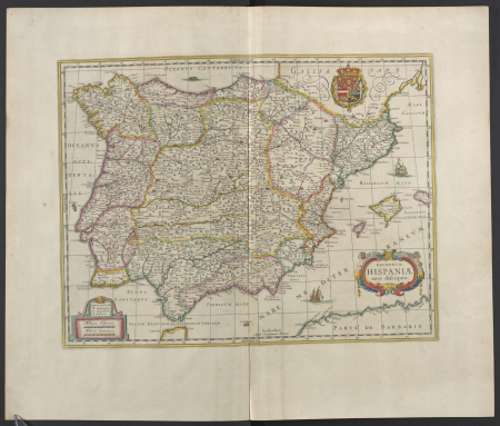
atlas maior, vol 10 (spain and africa) - joan blaeu, 1667 - bl 114.h(star).10
1667 maps
atlas maior, vol 5 (england) - joan blaeu, 1667 - bl 114.h(star).5
old county maps of caernarfonshire
atlas maior, vol 5 (england) - joan blaeu, 1667 - bl 114.h(star).5
old county maps of caernarfonshire
atlas maior, vol 10 (spain and africa) - joan blaeu, 1667 - bl 114.h(star).10
1667 maps
19th-century maps of the black sea
1870s maps of the caucasus
pictorial maps of the world
1876 maps of the world
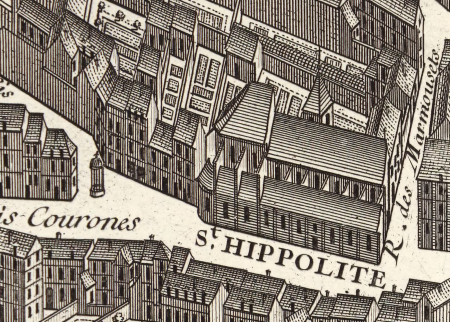
ancienne église saint-hippolyte de paris
churches on turgot map of paris
jan karel donatus van beecq
hernán cortés
maps of paris from the barry lawrence ruderman antique maps inc.
plan de turgot
maps from the portail des bibliothèques spécialisées de la ville de paris
maps from the bibliothèque historique de la ville de paris
1660s maps of pernambuco
1660s maps of brazil
john rocque's 1746 map of london
maps of woolwich
john rocque's 1746 map of london
maps of woolwich
copper engravings
maps by hattinga
copper engravings
maps by hattinga
war of jenkins' ear
edward vernon
war of jenkins' ear
edward vernon
17th-century maps of the mediterranean sea
copper engravings
19th-century maps of the black sea
g. h. swanston
maps by girolamo porro
1572 maps
fatland (audubon, pennsylvania)
valley forge
maps by girolamo porro
1572 maps
16th-century maps of the persian gulf
16th-century maps of the red sea
english county maps by john ogilby
old county maps of middlesex
english county maps by john ogilby
old county maps of middlesex
17th-century maps of the mediterranean sea
copper engravings
maps by johann christoph weigel
maps by christoph weigel
19th-century maps of the black sea
g. h. swanston
17th-century engravings
coenraet decker
eran laor cartographic collection
edward weller
jan karel donatus van beecq
hernán cortés
daniel friedrich sotzmann
grosser deutscher atlas
maps of liège in the 17th century
baroque
old maps of the carolingian empire
atlas van loon
old maps of the carolingian empire
atlas van loon
maps from the portail des bibliothèques spécialisées de la ville de paris
maps from the bibliothèque historique de la ville de paris
a voyage to abyssinia, and travels into the interior of that country, executed under the orders of the british government in the years 1809 & 1810
john outhett
a voyage to abyssinia, and travels into the interior of that country, executed under the orders of the british government in the years 1809 & 1810
john outhett
atlas van der hagen (volume 3)
atlas van der hagen
atlas maior, vol 10 (spain and africa) - joan blaeu, 1667 - bl 114.h(star).10
1667 maps of europe
1660s maps of spain
1667 maps
atlas maior, vol 10 (spain and africa) - joan blaeu, 1667 - bl 114.h(star).10
1667 maps of europe
901 - 1000 of 12,780
Next page
/ 128


![Hambvrgvm / [Georg Braun. Franz Hogenberg], Frans Hogenberg, circa 1590](https://cdn.creazilla.com/illustrations/10001490839/hambvrgvm-georg-braun-franz-hogenberg-frans-hogenberg-circa-1590-md.jpg)


![Stadsprofiel van] VENETIA, Joan Blaeu, 1704](https://cdn.creazilla.com/illustrations/10000311106/stadsprofiel-van-venetia-joan-blaeu-1704-md.jpeg)